GEOGRAPHY MYP/GCSE/DP
  • Home
    • Contact
  • MYP
    • Development >
      • An unequal world?
      • Billionaires investigation
      • Africa: the danger of a single story
      • Patterns of development
      • Trade and development
      • Fair Trade
      • Sustainable Development Goals
    • Tectonic Hazards >
      • What is risk?
      • Alfred Wegener and Continental Drift
      • Plate tectonics
      • Distribution of tectonic hazards
      • Measuring earthquakes
      • Why do people die in earthquakes?
      • School earthquake plan
      • Earthquake assessment
      • Volcanoes - what are they? Why are they important?
      • Volcano "Science Fair"
      • Causes of tsunami
    • Population >
      • Why study population?
      • Population distribution
      • Population growth
      • Population pyramids
      • Demographic transition model
      • Migration
      • Migration examples - case studies
      • Refugees in Indonesia
      • Population revision activities
    • Weather and Climate >
      • Weather vs Climate and why is it important?
      • Climate graphs
      • Why does it rain?
      • What affects temperature and why is Jakarta so hot and wet?
      • What causes wind and how do we measure it?
      • Microclimates
  • IGCSE
    • Course information
    • Physical: Hazardous environments >
      • Distribution of tectonic hazards
      • Causes of tsunami
      • Measuring earthquakes
      • Earthquake case study 1: Haiti
      • Earthquake case study 2: Christchurch
      • Why do earthquakes do more damage in LICs than in HICs?
      • How are volcanic eruptions measured?
      • Tropical storms - distribution
      • Causes of tropical cyclones
      • Tropical cyclones - case study
      • Why live in hazardous areas?
    • River Environments >
      • Hydrological cycle
      • River basins
      • Factors affecting river regimes
      • Fluvial processes: erosion
      • Fluvial processes: weathering and mass movement
      • Fluvial processes: transportation and depositon
      • River features and their formation
      • How rivers change from source to mouth
      • Uses of water
      • Water pollution
      • Water supply
  • IBDP
    • Changing population >
      • Global patterns of economic development
      • Physical and human factors affecting global population distribution
      • Case study 1: China
      • Case study 2: Niger
      • Demographic transition
      • Megacity growth
      • Forced migration and internal displacement
      • Ageing populations
      • Pro-natalist and anti-natalist policies
      • Gender equality policies
      • Trafficking policies
      • The Demographic Dividend
    • Global climate vulnerability and resilience >
      • Atmospheric system
      • The energy balance
      • Changes in the energy balance
      • The enhanced greenhouse effect
      • Climate Change and the Hydrosphere, Atmosphere and Biosphere
      • Impacts of climate change on people and places
      • Disparities in exposure to climate change risk and vulnerability
      • Government-led adaptation and mitigation strategies
      • Civil society and corporate strategies
    • Global resource consumption and security >
      • Progress towards poverty reduction
      • Measuring trends in global consumption
      • Global patterns and trends in the availability and consumption of water
      • Global patterns and trends in the availability and consumption of land/food
      • Global patterns and trends in the availability and consumption of energy
      • Water food and energy nexus
      • Recycling and waste
      • Malthus vs Boserup
      • Resource Stewardship strategies
      • Sustainable Development Goals
    • Freshwater - drainage basins >
      • The drainage basin as a system
      • How rivers change from source to mouth
      • River discharge
      • River processes
      • River landforms
      • Factors affecting flood risk
      • Attempts at flood prediction
      • Flood mitigation
      • Flood mitigation case studies
      • Water scarcity
      • Agricultural activities and water quality
      • Pressures on lakes and aquifers
      • Internationally shared water and conflict
      • Water management: participation of local communities
      • Dams as multi-purpose schemes
      • Water management: Integrated Drainage Basin Management (IDBM)
      • Managing wetlands
    • Leisure, Sport and Tourism >
      • Growth and purpose of leisure time
      • Categories of tourism and sport
      • Economic development and participation
      • Factors affecting personal participation
      • Factors affecting growth of tourism hotspots
      • Spheres of influencee
      • Factors affecting a national sports league
      • Festivals
      • Niche national tourism strategies
      • Role of TNCs
      • Tourism as a national development strategy
      • International sporting events
      • Consequences of unsustainable growth
      • Sustainable tourism
      • Future international tourism
      • Political and cultural influences on sport
    • Extended Essay in Geography >
      • Supervisor meetings
    • Skills/concepts >
      • Infographics
      • 4 Ps
      • Mock examination revision and preparation
  • Geography and ToK
  • Theory of Knowledge
    • Knowledge and Technology
    • Knowledge and Language
    • Knowledge and Politics
    • Knowledge and Religion
    • Knowledge and Indigenous Societies

A. Distribution of earthquakes

Examine the active map on the Seismic Monitor website (link from image below). What patterns can you identify in where earthquakes occur globally? 
Picture
Picture
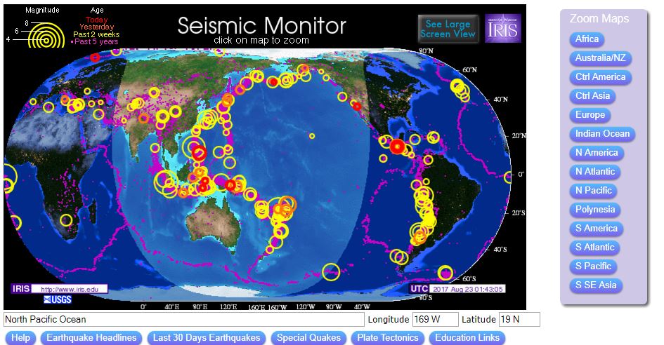
1. Plot the location of all of the earthquakes onto a map. Ensure that you create a key which identifies which is which. You should also include the magnitude and death toll. Your map should be clear and show care and attention to detail.

B. Distribution of volcanoes

Picture
Picture
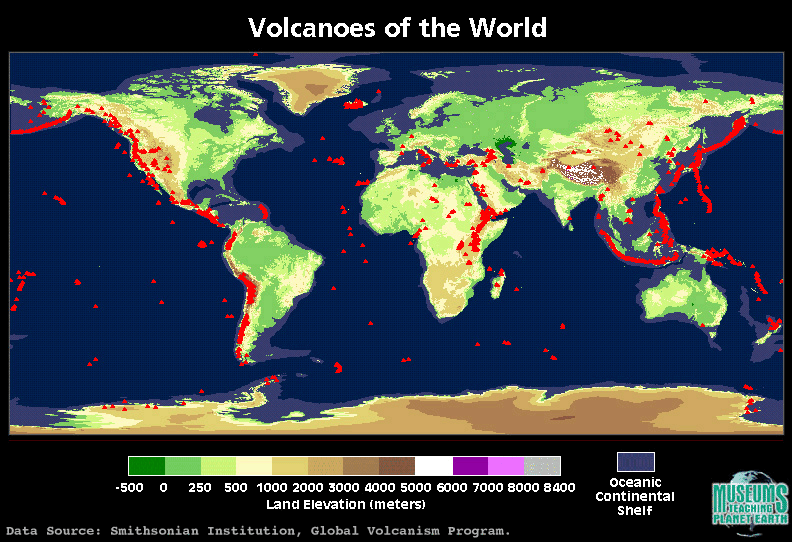
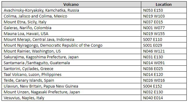
2. Add the volcanoes listed above to your map.
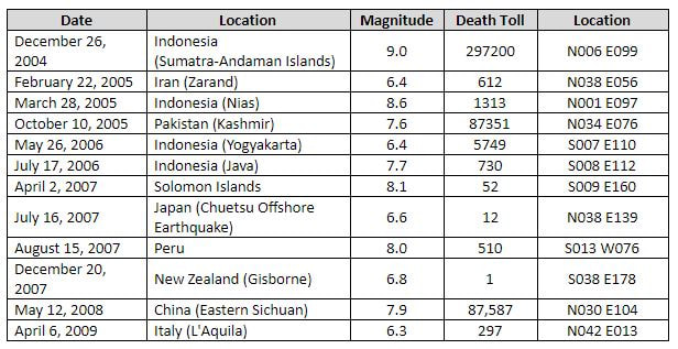
​3. Through your own research, add to the list of earthquakes and volcanoes with any which have been in the news in recent years.

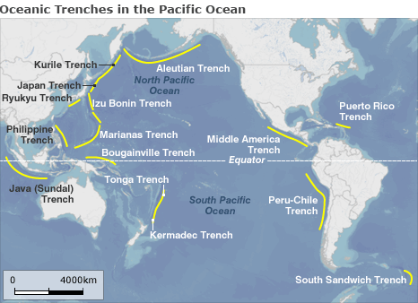
4. Research where “Fold Mountains” are found globally. Add some major fold mountains to your map. You could even include ocean trenches.

Fold mountains from Geography Pods: www.geographypods.com/4-fold-mountains.html

Picture
Picture
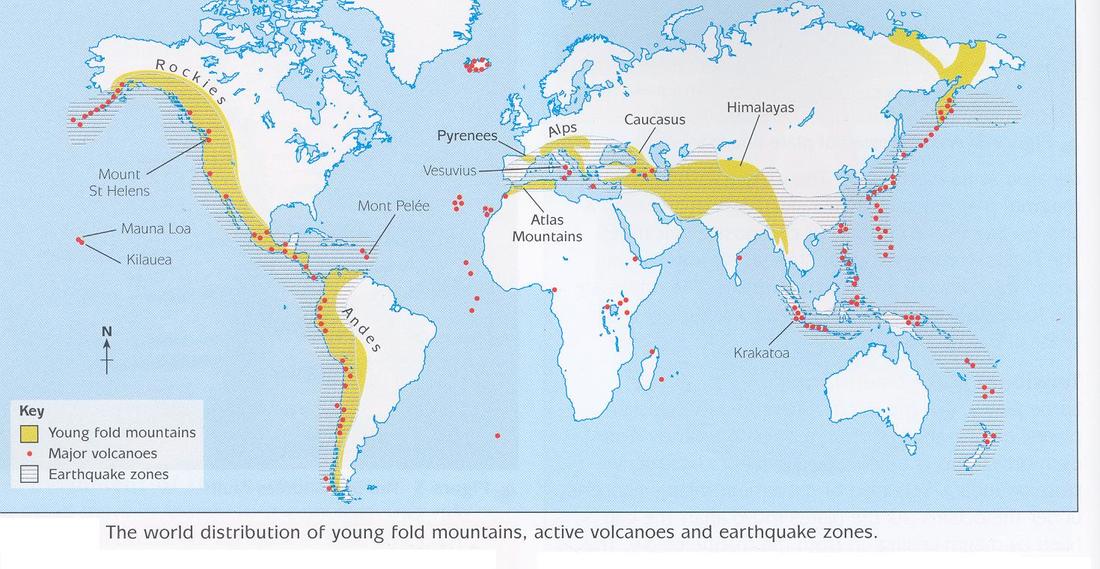
 5. Write a detailed written account of the distribution patterns shown. You should consider annotating your map.

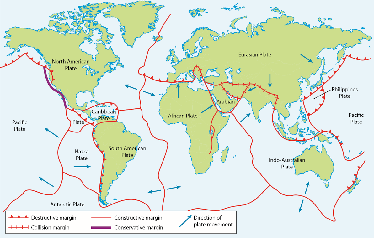
What are the overall patterns? Where in the world is there a concentration? Where is there no evidence of tectonic activity? Use place specific language – names of countries, oceans and continents, directions, descriptive terms (clustered, nucleated, linear, dispersed). How are the the locations of earthquakes, volcanoes, oceanic trenches and fold mountains connected?

6. 
Identify any anomalies and add these to your description.​

7. Use the student book and/or the information on Greenfield and BBC Bitesize (links below)
 to write an extended paragraph explaining the patterns you identified from your own map.

8. 
Do some additional research to explain any anomalies e.g. Hawaii.

9. How does what you have read help to explain the location of fold mountains and ocean trenches?
Picture
Picture

Plate tectonics

Mini-lesson planning task

In your groups, work collaboratively to create a mini-lesson plan to deliver to the rest of the class. Your learning outcomes are:
  • Be able to describe and explain the physical processes at the plate boundary
  • Understand the link between the physical processes and the creation of earthquakes and/or volcanoes.
  • Be able to name and locate examples of this kind of boundary and of earthquakes/volcanic events which have occurred there.

By the end of your lesson, students should have achieved the learning above and should be able to annotate a diagram of the boundary you have explained.
Picture
Picture

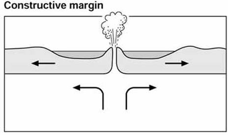
Constructive boundaries

Picture
BBC Bitesize
s-cool.co.uk

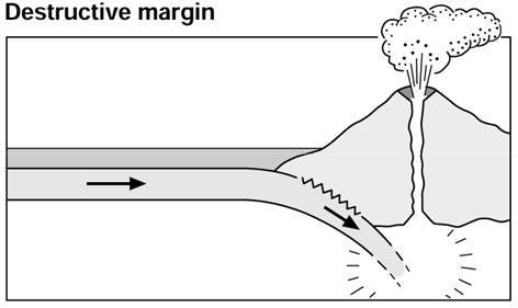
Destructive boundaries/subduction zones

Picture
s-cool.co.uk
BBC Bitesize

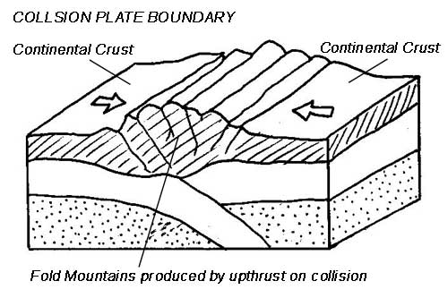
Collision boundaries

Picture
s-cool.co.uk
BBC Bitesize

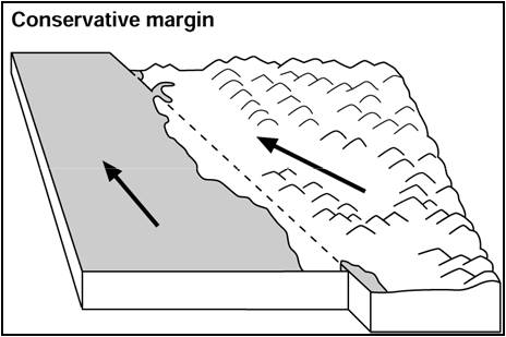
Conservative boundaries
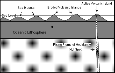
Picture
s-cool.co.uk
BBC Bitesize

Hot spot

Picture
US NOAA explanation
BBC Science

Additional material

  • Home
    • Contact
  • MYP
    • Development >
      • An unequal world?
      • Billionaires investigation
      • Africa: the danger of a single story
      • Patterns of development
      • Trade and development
      • Fair Trade
      • Sustainable Development Goals
    • Tectonic Hazards >
      • What is risk?
      • Alfred Wegener and Continental Drift
      • Plate tectonics
      • Distribution of tectonic hazards
      • Measuring earthquakes
      • Why do people die in earthquakes?
      • School earthquake plan
      • Earthquake assessment
      • Volcanoes - what are they? Why are they important?
      • Volcano "Science Fair"
      • Causes of tsunami
    • Population >
      • Why study population?
      • Population distribution
      • Population growth
      • Population pyramids
      • Demographic transition model
      • Migration
      • Migration examples - case studies
      • Refugees in Indonesia
      • Population revision activities
    • Weather and Climate >
      • Weather vs Climate and why is it important?
      • Climate graphs
      • Why does it rain?
      • What affects temperature and why is Jakarta so hot and wet?
      • What causes wind and how do we measure it?
      • Microclimates
  • IGCSE
    • Course information
    • Physical: Hazardous environments >
      • Distribution of tectonic hazards
      • Causes of tsunami
      • Measuring earthquakes
      • Earthquake case study 1: Haiti
      • Earthquake case study 2: Christchurch
      • Why do earthquakes do more damage in LICs than in HICs?
      • How are volcanic eruptions measured?
      • Tropical storms - distribution
      • Causes of tropical cyclones
      • Tropical cyclones - case study
      • Why live in hazardous areas?
    • River Environments >
      • Hydrological cycle
      • River basins
      • Factors affecting river regimes
      • Fluvial processes: erosion
      • Fluvial processes: weathering and mass movement
      • Fluvial processes: transportation and depositon
      • River features and their formation
      • How rivers change from source to mouth
      • Uses of water
      • Water pollution
      • Water supply
  • IBDP
    • Changing population >
      • Global patterns of economic development
      • Physical and human factors affecting global population distribution
      • Case study 1: China
      • Case study 2: Niger
      • Demographic transition
      • Megacity growth
      • Forced migration and internal displacement
      • Ageing populations
      • Pro-natalist and anti-natalist policies
      • Gender equality policies
      • Trafficking policies
      • The Demographic Dividend
    • Global climate vulnerability and resilience >
      • Atmospheric system
      • The energy balance
      • Changes in the energy balance
      • The enhanced greenhouse effect
      • Climate Change and the Hydrosphere, Atmosphere and Biosphere
      • Impacts of climate change on people and places
      • Disparities in exposure to climate change risk and vulnerability
      • Government-led adaptation and mitigation strategies
      • Civil society and corporate strategies
    • Global resource consumption and security >
      • Progress towards poverty reduction
      • Measuring trends in global consumption
      • Global patterns and trends in the availability and consumption of water
      • Global patterns and trends in the availability and consumption of land/food
      • Global patterns and trends in the availability and consumption of energy
      • Water food and energy nexus
      • Recycling and waste
      • Malthus vs Boserup
      • Resource Stewardship strategies
      • Sustainable Development Goals
    • Freshwater - drainage basins >
      • The drainage basin as a system
      • How rivers change from source to mouth
      • River discharge
      • River processes
      • River landforms
      • Factors affecting flood risk
      • Attempts at flood prediction
      • Flood mitigation
      • Flood mitigation case studies
      • Water scarcity
      • Agricultural activities and water quality
      • Pressures on lakes and aquifers
      • Internationally shared water and conflict
      • Water management: participation of local communities
      • Dams as multi-purpose schemes
      • Water management: Integrated Drainage Basin Management (IDBM)
      • Managing wetlands
    • Leisure, Sport and Tourism >
      • Growth and purpose of leisure time
      • Categories of tourism and sport
      • Economic development and participation
      • Factors affecting personal participation
      • Factors affecting growth of tourism hotspots
      • Spheres of influencee
      • Factors affecting a national sports league
      • Festivals
      • Niche national tourism strategies
      • Role of TNCs
      • Tourism as a national development strategy
      • International sporting events
      • Consequences of unsustainable growth
      • Sustainable tourism
      • Future international tourism
      • Political and cultural influences on sport
    • Extended Essay in Geography >
      • Supervisor meetings
    • Skills/concepts >
      • Infographics
      • 4 Ps
      • Mock examination revision and preparation
  • Geography and ToK
  • Theory of Knowledge
    • Knowledge and Technology
    • Knowledge and Language
    • Knowledge and Politics
    • Knowledge and Religion
    • Knowledge and Indigenous Societies