GEOGRAPHY MYP/GCSE/DP
  • Home
    • Contact
  • MYP
    • Development >
      • An unequal world?
      • Billionaires investigation
      • Africa: the danger of a single story
      • Patterns of development
      • Trade and development
      • Fair Trade
      • Sustainable Development Goals
    • Tectonic Hazards >
      • What is risk?
      • Alfred Wegener and Continental Drift
      • Plate tectonics
      • Distribution of tectonic hazards
      • Measuring earthquakes
      • Why do people die in earthquakes?
      • School earthquake plan
      • Earthquake assessment
      • Volcanoes - what are they? Why are they important?
      • Volcano "Science Fair"
      • Causes of tsunami
    • Population >
      • Why study population?
      • Population distribution
      • Population growth
      • Population pyramids
      • Demographic transition model
      • Migration
      • Migration examples - case studies
      • Refugees in Indonesia
      • Population revision activities
    • Weather and Climate >
      • Weather vs Climate and why is it important?
      • Climate graphs
      • Why does it rain?
      • What affects temperature and why is Jakarta so hot and wet?
      • What causes wind and how do we measure it?
      • Microclimates
  • IGCSE
    • Course information
    • Physical: Hazardous environments >
      • Distribution of tectonic hazards
      • Causes of tsunami
      • Measuring earthquakes
      • Earthquake case study 1: Haiti
      • Earthquake case study 2: Christchurch
      • Why do earthquakes do more damage in LICs than in HICs?
      • How are volcanic eruptions measured?
      • Tropical storms - distribution
      • Causes of tropical cyclones
      • Tropical cyclones - case study
      • Why live in hazardous areas?
    • River Environments >
      • Hydrological cycle
      • River basins
      • Factors affecting river regimes
      • Fluvial processes: erosion
      • Fluvial processes: weathering and mass movement
      • Fluvial processes: transportation and depositon
      • River features and their formation
      • How rivers change from source to mouth
      • Uses of water
      • Water pollution
      • Water supply
  • IBDP
    • Changing population >
      • Global patterns of economic development
      • Physical and human factors affecting global population distribution
      • Case study 1: China
      • Case study 2: Niger
      • Demographic transition
      • Megacity growth
      • Forced migration and internal displacement
      • Ageing populations
      • Pro-natalist and anti-natalist policies
      • Gender equality policies
      • Trafficking policies
      • The Demographic Dividend
    • Global climate vulnerability and resilience >
      • Atmospheric system
      • The energy balance
      • Changes in the energy balance
      • The enhanced greenhouse effect
      • Climate Change and the Hydrosphere, Atmosphere and Biosphere
      • Impacts of climate change on people and places
      • Disparities in exposure to climate change risk and vulnerability
      • Government-led adaptation and mitigation strategies
      • Civil society and corporate strategies
    • Global resource consumption and security >
      • Progress towards poverty reduction
      • Measuring trends in global consumption
      • Global patterns and trends in the availability and consumption of water
      • Global patterns and trends in the availability and consumption of land/food
      • Global patterns and trends in the availability and consumption of energy
      • Water food and energy nexus
      • Recycling and waste
      • Malthus vs Boserup
      • Resource Stewardship strategies
      • Sustainable Development Goals
    • Freshwater - drainage basins >
      • The drainage basin as a system
      • How rivers change from source to mouth
      • River discharge
      • River processes
      • River landforms
      • Factors affecting flood risk
      • Attempts at flood prediction
      • Flood mitigation
      • Flood mitigation case studies
      • Water scarcity
      • Agricultural activities and water quality
      • Pressures on lakes and aquifers
      • Internationally shared water and conflict
      • Water management: participation of local communities
      • Dams as multi-purpose schemes
      • Water management: Integrated Drainage Basin Management (IDBM)
      • Managing wetlands
    • Leisure, Sport and Tourism >
      • Growth and purpose of leisure time
      • Categories of tourism and sport
      • Economic development and participation
      • Factors affecting personal participation
      • Factors affecting growth of tourism hotspots
      • Spheres of influencee
      • Factors affecting a national sports league
      • Festivals
      • Niche national tourism strategies
      • Role of TNCs
      • Tourism as a national development strategy
      • International sporting events
      • Consequences of unsustainable growth
      • Sustainable tourism
      • Future international tourism
      • Political and cultural influences on sport
    • Extended Essay in Geography >
      • Supervisor meetings
    • Skills/concepts >
      • Infographics
      • 4 Ps
      • Mock examination revision and preparation
  • Geography and ToK
  • Theory of Knowledge
    • Knowledge and Technology
    • Knowledge and Language
    • Knowledge and Politics
    • Knowledge and Religion
    • Knowledge and Indigenous Societies

Plate Tectonics 

Plate Tectonics

What do you need to know?
  • The structure of the earth - the different layers and their characteristics
  • How and why plates move and how it supports Wegener's ideas
  • Location and characteristics of the plates
  • What happens at plate boundaries and how this leads to earthquakes, tsunami and volcanoes

1. From Wegener to Plate Tectonics

Wegener's ideas were rejected by his contemporaries and he died in Greenland without ever knowing how Continental Drift occurred or having his ideas accepted. So how did we get from that to what we believe today?

Along came Harry Hess... 
  1. Who was Harry Hess?
  2. What did he discover? How and why did he discover it?
  3. What did oceanographers discover in the Atlantic in 1953 and what was it called?
  4. How high are the mountains in the middle of the Atlantic? 
  5. What did Hess discover about the rocks in the Mid-Atlantic Ridge? 
  6. Why is this significant?
  7. What were Hess's conclusions about what was happening at the Mid-Atlantic Ridge? 
  8. What did he call it?
  9. Why is the earth not getting bigger if new crust is being created?

​Start watching the video on the left at 6 minutes 30 seconds.
​
  1. By the 1960s what theory had both Hess' and Wegener's ideas been combined to create?
  2. What are plates? How fast do they move?
  3. If they move so slowly, why is this important?
  4. What is going to happen to the continents over the next millions of years?
  5. What are some of the consequences of this plate movement - give some examples.

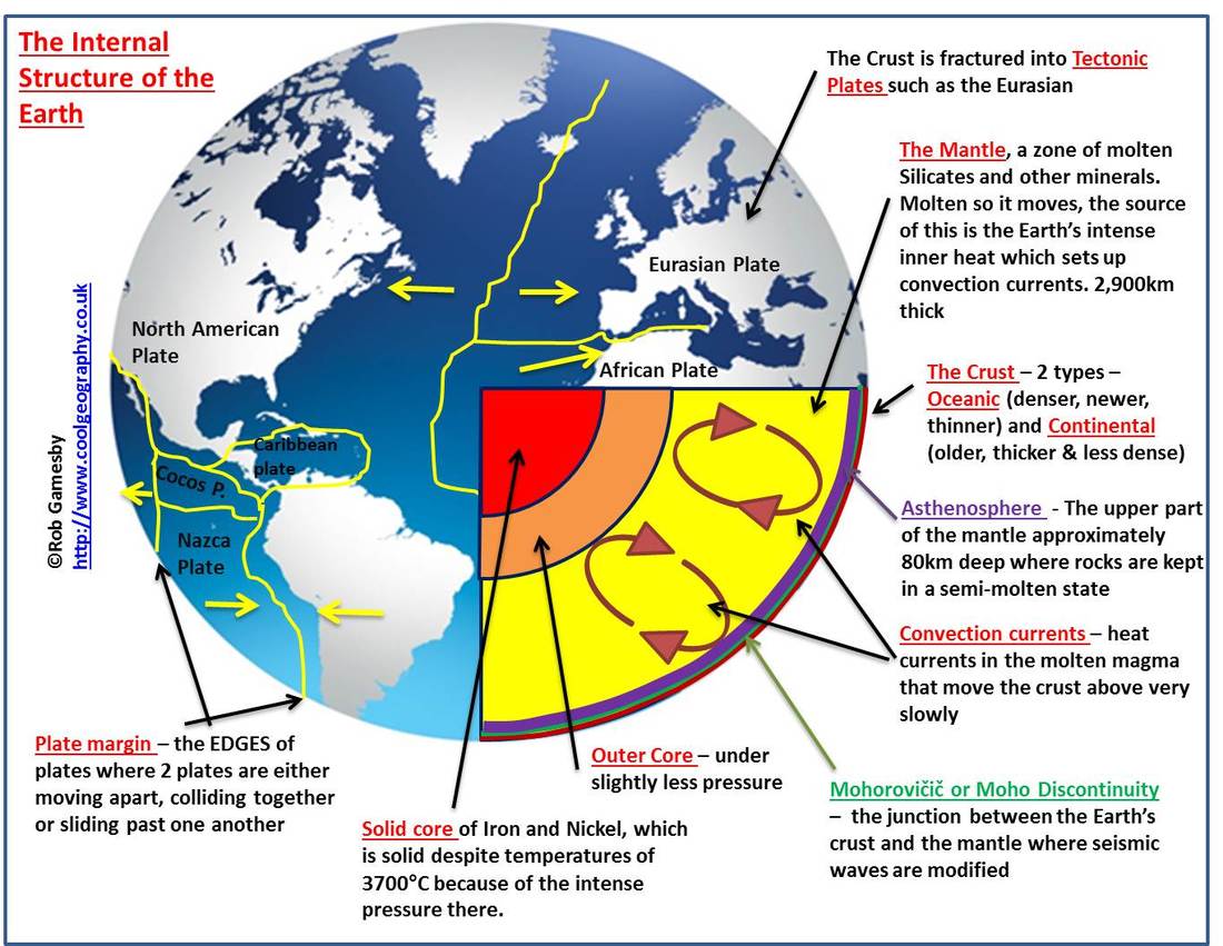
2. The Structure of the Earth

Annotated diagram of the structure of the earth
Remember the basics:
  • Plan carefully - you will need room for your annotations. 
  • Title (clear, bold, says exactly what your diagram will show).
  • Frame (pencil and ruler).
  • Key (what do the colours mean if you use them?
  • Colour only if needed and chosen carefully (not just for decoration).
  • Annotation can be inside or outside the frame but be consistent.
  • Arrows drawn with a ruler. 
  • Arrows must not cross!!
  • Keep it simple. It will be easier to draw simple circles than to try to create a 3D drawing.
Picture
What should the diagram include?
  • Clear, to approximate scale representation of the layers: crust, mantle, outer and inner core
  • Annotation which shows the thickness of each layer (metric - so make sure you use km not miles!)
  • Annotation for each layer which will include: what it is made of, its characteristics (molten/solid? moving/static?)
  • Explanation of two types of crust (continental and oceanic) and their differences.
  • Asthenosphere
  • Moho Discontinuity
  • Lithosphere

3. How do we know about the layers?


​Even the deepest hole ever drilled on our planet (in Western Russia - check the SciSchow video below) is only 12km deep which is less than

So, how do we know about the earth's structure?

This video should help you to understand.

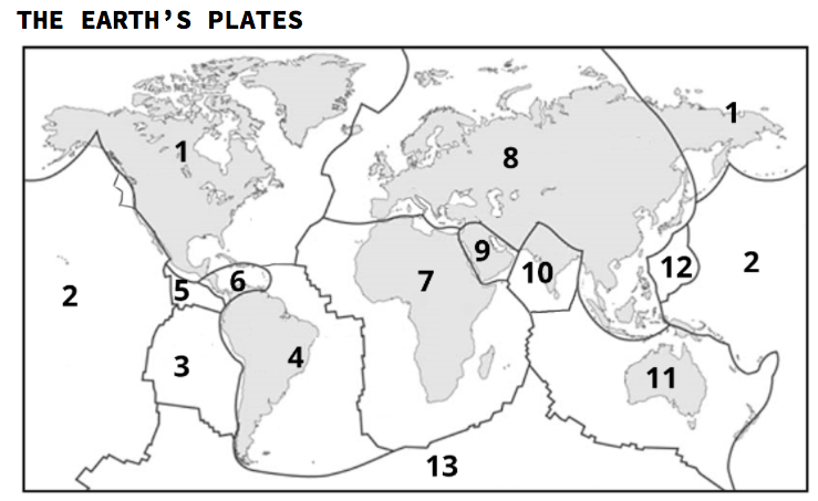
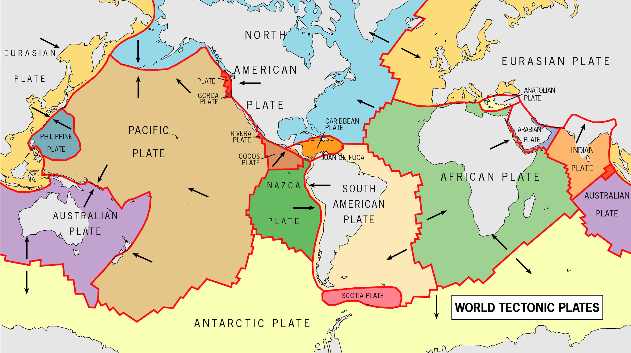
4. Plate Tectonics: the earth's plates

  1. What are plates?
  2. Why is the type of crust (oceanic or continental) important?
  3. What makes them move

CLICK ON THE IMAGE BELOW TO OPEN A BLANK MAP AND KEY OF THE EARTH'S PLATES.
Picture
Picture

5. Plate tectonics: Why do the plates move?

6. Extra - worth a look

  • Home
    • Contact
  • MYP
    • Development >
      • An unequal world?
      • Billionaires investigation
      • Africa: the danger of a single story
      • Patterns of development
      • Trade and development
      • Fair Trade
      • Sustainable Development Goals
    • Tectonic Hazards >
      • What is risk?
      • Alfred Wegener and Continental Drift
      • Plate tectonics
      • Distribution of tectonic hazards
      • Measuring earthquakes
      • Why do people die in earthquakes?
      • School earthquake plan
      • Earthquake assessment
      • Volcanoes - what are they? Why are they important?
      • Volcano "Science Fair"
      • Causes of tsunami
    • Population >
      • Why study population?
      • Population distribution
      • Population growth
      • Population pyramids
      • Demographic transition model
      • Migration
      • Migration examples - case studies
      • Refugees in Indonesia
      • Population revision activities
    • Weather and Climate >
      • Weather vs Climate and why is it important?
      • Climate graphs
      • Why does it rain?
      • What affects temperature and why is Jakarta so hot and wet?
      • What causes wind and how do we measure it?
      • Microclimates
  • IGCSE
    • Course information
    • Physical: Hazardous environments >
      • Distribution of tectonic hazards
      • Causes of tsunami
      • Measuring earthquakes
      • Earthquake case study 1: Haiti
      • Earthquake case study 2: Christchurch
      • Why do earthquakes do more damage in LICs than in HICs?
      • How are volcanic eruptions measured?
      • Tropical storms - distribution
      • Causes of tropical cyclones
      • Tropical cyclones - case study
      • Why live in hazardous areas?
    • River Environments >
      • Hydrological cycle
      • River basins
      • Factors affecting river regimes
      • Fluvial processes: erosion
      • Fluvial processes: weathering and mass movement
      • Fluvial processes: transportation and depositon
      • River features and their formation
      • How rivers change from source to mouth
      • Uses of water
      • Water pollution
      • Water supply
  • IBDP
    • Changing population >
      • Global patterns of economic development
      • Physical and human factors affecting global population distribution
      • Case study 1: China
      • Case study 2: Niger
      • Demographic transition
      • Megacity growth
      • Forced migration and internal displacement
      • Ageing populations
      • Pro-natalist and anti-natalist policies
      • Gender equality policies
      • Trafficking policies
      • The Demographic Dividend
    • Global climate vulnerability and resilience >
      • Atmospheric system
      • The energy balance
      • Changes in the energy balance
      • The enhanced greenhouse effect
      • Climate Change and the Hydrosphere, Atmosphere and Biosphere
      • Impacts of climate change on people and places
      • Disparities in exposure to climate change risk and vulnerability
      • Government-led adaptation and mitigation strategies
      • Civil society and corporate strategies
    • Global resource consumption and security >
      • Progress towards poverty reduction
      • Measuring trends in global consumption
      • Global patterns and trends in the availability and consumption of water
      • Global patterns and trends in the availability and consumption of land/food
      • Global patterns and trends in the availability and consumption of energy
      • Water food and energy nexus
      • Recycling and waste
      • Malthus vs Boserup
      • Resource Stewardship strategies
      • Sustainable Development Goals
    • Freshwater - drainage basins >
      • The drainage basin as a system
      • How rivers change from source to mouth
      • River discharge
      • River processes
      • River landforms
      • Factors affecting flood risk
      • Attempts at flood prediction
      • Flood mitigation
      • Flood mitigation case studies
      • Water scarcity
      • Agricultural activities and water quality
      • Pressures on lakes and aquifers
      • Internationally shared water and conflict
      • Water management: participation of local communities
      • Dams as multi-purpose schemes
      • Water management: Integrated Drainage Basin Management (IDBM)
      • Managing wetlands
    • Leisure, Sport and Tourism >
      • Growth and purpose of leisure time
      • Categories of tourism and sport
      • Economic development and participation
      • Factors affecting personal participation
      • Factors affecting growth of tourism hotspots
      • Spheres of influencee
      • Factors affecting a national sports league
      • Festivals
      • Niche national tourism strategies
      • Role of TNCs
      • Tourism as a national development strategy
      • International sporting events
      • Consequences of unsustainable growth
      • Sustainable tourism
      • Future international tourism
      • Political and cultural influences on sport
    • Extended Essay in Geography >
      • Supervisor meetings
    • Skills/concepts >
      • Infographics
      • 4 Ps
      • Mock examination revision and preparation
  • Geography and ToK
  • Theory of Knowledge
    • Knowledge and Technology
    • Knowledge and Language
    • Knowledge and Politics
    • Knowledge and Religion
    • Knowledge and Indigenous Societies