GEOGRAPHY MYP/GCSE/DP
  • Home
    • Contact
  • MYP
    • Development >
      • An unequal world?
      • Billionaires investigation
      • Africa: the danger of a single story
      • Patterns of development
      • Trade and development
      • Fair Trade
      • Sustainable Development Goals
    • Tectonic Hazards >
      • What is risk?
      • Alfred Wegener and Continental Drift
      • Plate tectonics
      • Distribution of tectonic hazards
      • Measuring earthquakes
      • Why do people die in earthquakes?
      • School earthquake plan
      • Earthquake assessment
      • Volcanoes - what are they? Why are they important?
      • Volcano "Science Fair"
      • Causes of tsunami
    • Population >
      • Why study population?
      • Population distribution
      • Population growth
      • Population pyramids
      • Demographic transition model
      • Migration
      • Migration examples - case studies
      • Refugees in Indonesia
      • Population revision activities
    • Weather and Climate >
      • Weather vs Climate and why is it important?
      • Climate graphs
      • Why does it rain?
      • What affects temperature and why is Jakarta so hot and wet?
      • What causes wind and how do we measure it?
      • Microclimates
  • IGCSE
    • Course information
    • Physical: Hazardous environments >
      • Distribution of tectonic hazards
      • Causes of tsunami
      • Measuring earthquakes
      • Earthquake case study 1: Haiti
      • Earthquake case study 2: Christchurch
      • Why do earthquakes do more damage in LICs than in HICs?
      • How are volcanic eruptions measured?
      • Tropical storms - distribution
      • Causes of tropical cyclones
      • Tropical cyclones - case study
      • Why live in hazardous areas?
    • River Environments >
      • Hydrological cycle
      • River basins
      • Factors affecting river regimes
      • Fluvial processes: erosion
      • Fluvial processes: weathering and mass movement
      • Fluvial processes: transportation and depositon
      • River features and their formation
      • How rivers change from source to mouth
      • Uses of water
      • Water pollution
      • Water supply
  • IBDP
    • Changing population >
      • Global patterns of economic development
      • Physical and human factors affecting global population distribution
      • Case study 1: China
      • Case study 2: Niger
      • Demographic transition
      • Megacity growth
      • Forced migration and internal displacement
      • Ageing populations
      • Pro-natalist and anti-natalist policies
      • Gender equality policies
      • Trafficking policies
      • The Demographic Dividend
    • Global climate vulnerability and resilience >
      • Atmospheric system
      • The energy balance
      • Changes in the energy balance
      • The enhanced greenhouse effect
      • Climate Change and the Hydrosphere, Atmosphere and Biosphere
      • Impacts of climate change on people and places
      • Disparities in exposure to climate change risk and vulnerability
      • Government-led adaptation and mitigation strategies
      • Civil society and corporate strategies
    • Global resource consumption and security >
      • Progress towards poverty reduction
      • Measuring trends in global consumption
      • Global patterns and trends in the availability and consumption of water
      • Global patterns and trends in the availability and consumption of land/food
      • Global patterns and trends in the availability and consumption of energy
      • Water food and energy nexus
      • Recycling and waste
      • Malthus vs Boserup
      • Resource Stewardship strategies
      • Sustainable Development Goals
    • Freshwater - drainage basins >
      • The drainage basin as a system
      • How rivers change from source to mouth
      • River discharge
      • River processes
      • River landforms
      • Factors affecting flood risk
      • Attempts at flood prediction
      • Flood mitigation
      • Flood mitigation case studies
      • Water scarcity
      • Agricultural activities and water quality
      • Pressures on lakes and aquifers
      • Internationally shared water and conflict
      • Water management: participation of local communities
      • Dams as multi-purpose schemes
      • Water management: Integrated Drainage Basin Management (IDBM)
      • Managing wetlands
    • Leisure, Sport and Tourism >
      • Growth and purpose of leisure time
      • Categories of tourism and sport
      • Economic development and participation
      • Factors affecting personal participation
      • Factors affecting growth of tourism hotspots
      • Spheres of influencee
      • Factors affecting a national sports league
      • Festivals
      • Niche national tourism strategies
      • Role of TNCs
      • Tourism as a national development strategy
      • International sporting events
      • Consequences of unsustainable growth
      • Sustainable tourism
      • Future international tourism
      • Political and cultural influences on sport
    • Extended Essay in Geography >
      • Supervisor meetings
    • Skills/concepts >
      • Infographics
      • 4 Ps
      • Mock examination revision and preparation
  • Geography and ToK
  • Theory of Knowledge
    • Knowledge and Technology
    • Knowledge and Language
    • Knowledge and Politics
    • Knowledge and Religion
    • Knowledge and Indigenous Societies

How rivers change from source to mouth

Subject Guide

River discharge and its relationship to stream flow, channel characteristics and hydraulic radius.
​This section has a strong link to the Geography IA.

Definitions

Channel shape: this is the shape of a cross section through the river channel itself. It is about the width and depth of the channel.

Valley profile: this is the shape of the valley on either side of the river channel. The measure it, we need to be able to measure the length and angle of the slopes perpendicular to the river.

Gradient: this is the steepness measured in degrees of the river as it flows downstream.

Velocity: this is the speed at which the water in the river is flowing, measures in metres per second.

Discharge: this is the volume of water flow my past a given point in the river per second. It is measured in cubic metres per second (CUMECS).

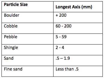
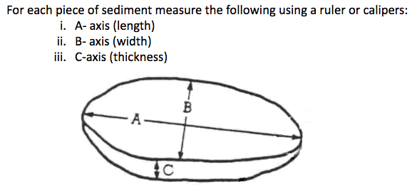
Sediment size: this is the mean size or the sediment carries by the river. We measure it in millimetres or centimetres. We can examine the A-axis, B-axis and C-exis.

Sediment shape: this is the roundness or roughness of the material carried by a river. It will be affected by attrition as the river moves downstream.
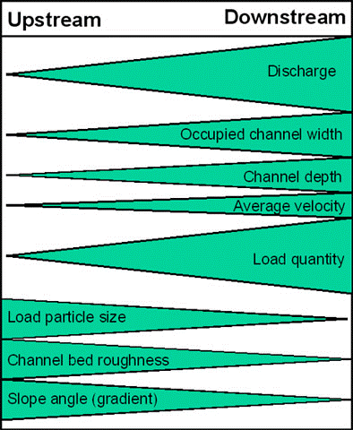
The Bradshaw Model

Picture
bradshaw_model.gslides
File Size: 314 kb
File Type: gslides
Download File

​
Use the materials above to answer the questions below in detail and using diagrams to help.
  1. What is the Bradshaw Model? How does it help us understand how a typical river is expected to change from source to mouth?
  2. How can a simplified model help us to study and understand the real world?
  3. For each aspect of the Bradshaw Model and load roughness describe the following using diagrams to help: how does the Bradshaw Model suggest it will change as a river moves downstream? Why are these changes expected? How would you measure this in the field to see if it applies to a particular river (use the file below to help).
​


How to measure river characteristics
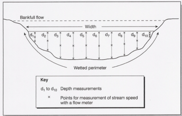
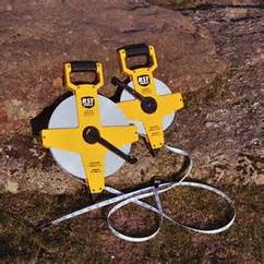
1. Channel Width
This is measured using a tape measure stretched across the channel. Measure the width across the surface of the water.  Record the measurement on the recording sheet.
​

2. Channel Depth
Take the width of the channel and divide it into 11 equal parts.
Measure the depth at the ten points across the channel. Always start from the same side; left or right when looking downstream.
Record the measurements on the recording sheet.
Picture
3. Cross-sectional area
To calculate this you use the formula below:

             Cross sectional area (m2)   =   Width of river (m)   x  Mean depth of river (m)  
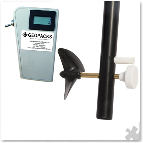
4. Velocity
To measure velocity we use a flow meter.
  • Using the flow meter measure the speed of the river flow at 5 equally spaced points across the channel.
  • ​At each point measure the speed at the surface, half way between the surface and the bed and at the river bed.
  • Record the measurements on the recording sheet.
Picture
5. Discharge
To measure discharge you must first have calculated the cross-sectional area using your as above. To calculate the discharge use the formula below:

Discharge (CUMECS)     =    Cross sectional area (m2)    x    Mean velocity ms-1

6. Sediment size
Sediment carried by the river is called its load. This will vary in size and shape depending on the hardness of the rocks and the time they have been in the river and affected by erosion (attrition).
  • Sediment can be measured with rulers or calipers.
  • Measure and record the length of the A, B and C axes (see diagram below).
Picture
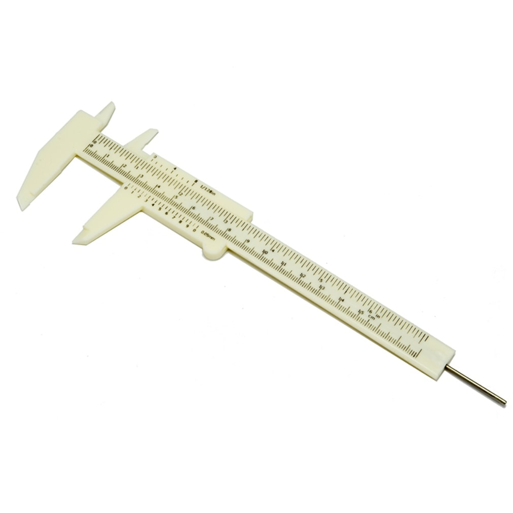
Calipers for measuring sediment size
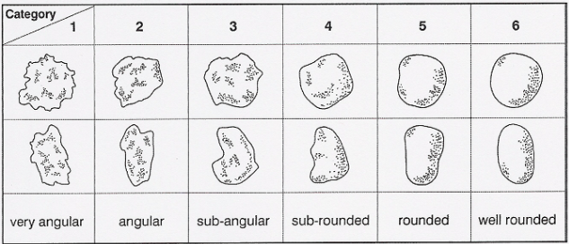
Picture
Picture

7. Sediment shape
Particle shape is determined by the rock type (geology) and the length of time erosion has been operating on it. Particle shape is measured by observation. It is therefore somewhat subjective. A sample of sediment is taken and the number of particles of different shapes and of particular roundness is recorded. They can be classified according to their roundness according to the Power’s Scale of Roundness, below:
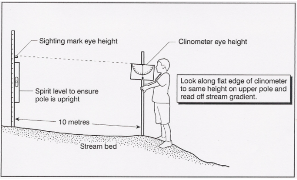
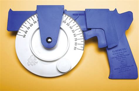
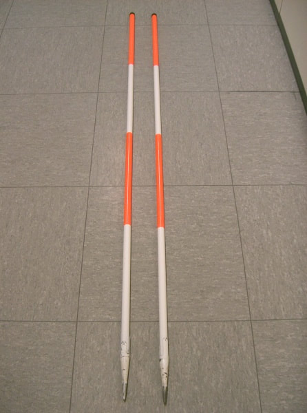
Picture

8. Gradient 
The gradient is the slope of the channel bed. This is important for river velocity and the flow characteristics of the channel.
  • To measure gradient take two ranging poles and place them in the channel at a distance of 10 meters apart. Use a clinometers to measure the angle between them.
  • Measure the angle three times and calculate an average to avoid measurement errors.
  • Record the measurements on the data sheet.

Picture
Picture
Picture
Picture


  • Home
    • Contact
  • MYP
    • Development >
      • An unequal world?
      • Billionaires investigation
      • Africa: the danger of a single story
      • Patterns of development
      • Trade and development
      • Fair Trade
      • Sustainable Development Goals
    • Tectonic Hazards >
      • What is risk?
      • Alfred Wegener and Continental Drift
      • Plate tectonics
      • Distribution of tectonic hazards
      • Measuring earthquakes
      • Why do people die in earthquakes?
      • School earthquake plan
      • Earthquake assessment
      • Volcanoes - what are they? Why are they important?
      • Volcano "Science Fair"
      • Causes of tsunami
    • Population >
      • Why study population?
      • Population distribution
      • Population growth
      • Population pyramids
      • Demographic transition model
      • Migration
      • Migration examples - case studies
      • Refugees in Indonesia
      • Population revision activities
    • Weather and Climate >
      • Weather vs Climate and why is it important?
      • Climate graphs
      • Why does it rain?
      • What affects temperature and why is Jakarta so hot and wet?
      • What causes wind and how do we measure it?
      • Microclimates
  • IGCSE
    • Course information
    • Physical: Hazardous environments >
      • Distribution of tectonic hazards
      • Causes of tsunami
      • Measuring earthquakes
      • Earthquake case study 1: Haiti
      • Earthquake case study 2: Christchurch
      • Why do earthquakes do more damage in LICs than in HICs?
      • How are volcanic eruptions measured?
      • Tropical storms - distribution
      • Causes of tropical cyclones
      • Tropical cyclones - case study
      • Why live in hazardous areas?
    • River Environments >
      • Hydrological cycle
      • River basins
      • Factors affecting river regimes
      • Fluvial processes: erosion
      • Fluvial processes: weathering and mass movement
      • Fluvial processes: transportation and depositon
      • River features and their formation
      • How rivers change from source to mouth
      • Uses of water
      • Water pollution
      • Water supply
  • IBDP
    • Changing population >
      • Global patterns of economic development
      • Physical and human factors affecting global population distribution
      • Case study 1: China
      • Case study 2: Niger
      • Demographic transition
      • Megacity growth
      • Forced migration and internal displacement
      • Ageing populations
      • Pro-natalist and anti-natalist policies
      • Gender equality policies
      • Trafficking policies
      • The Demographic Dividend
    • Global climate vulnerability and resilience >
      • Atmospheric system
      • The energy balance
      • Changes in the energy balance
      • The enhanced greenhouse effect
      • Climate Change and the Hydrosphere, Atmosphere and Biosphere
      • Impacts of climate change on people and places
      • Disparities in exposure to climate change risk and vulnerability
      • Government-led adaptation and mitigation strategies
      • Civil society and corporate strategies
    • Global resource consumption and security >
      • Progress towards poverty reduction
      • Measuring trends in global consumption
      • Global patterns and trends in the availability and consumption of water
      • Global patterns and trends in the availability and consumption of land/food
      • Global patterns and trends in the availability and consumption of energy
      • Water food and energy nexus
      • Recycling and waste
      • Malthus vs Boserup
      • Resource Stewardship strategies
      • Sustainable Development Goals
    • Freshwater - drainage basins >
      • The drainage basin as a system
      • How rivers change from source to mouth
      • River discharge
      • River processes
      • River landforms
      • Factors affecting flood risk
      • Attempts at flood prediction
      • Flood mitigation
      • Flood mitigation case studies
      • Water scarcity
      • Agricultural activities and water quality
      • Pressures on lakes and aquifers
      • Internationally shared water and conflict
      • Water management: participation of local communities
      • Dams as multi-purpose schemes
      • Water management: Integrated Drainage Basin Management (IDBM)
      • Managing wetlands
    • Leisure, Sport and Tourism >
      • Growth and purpose of leisure time
      • Categories of tourism and sport
      • Economic development and participation
      • Factors affecting personal participation
      • Factors affecting growth of tourism hotspots
      • Spheres of influencee
      • Factors affecting a national sports league
      • Festivals
      • Niche national tourism strategies
      • Role of TNCs
      • Tourism as a national development strategy
      • International sporting events
      • Consequences of unsustainable growth
      • Sustainable tourism
      • Future international tourism
      • Political and cultural influences on sport
    • Extended Essay in Geography >
      • Supervisor meetings
    • Skills/concepts >
      • Infographics
      • 4 Ps
      • Mock examination revision and preparation
  • Geography and ToK
  • Theory of Knowledge
    • Knowledge and Technology
    • Knowledge and Language
    • Knowledge and Politics
    • Knowledge and Religion
    • Knowledge and Indigenous Societies