The Subject Guide
Physical and human factors affecting population distribution at the global scale.
A. Global population density maps
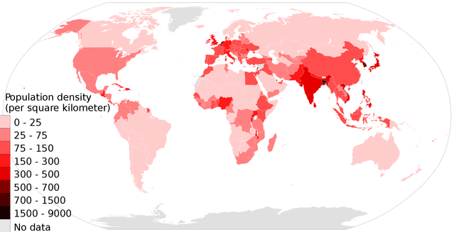
Map 1: Choropleth map showing population density by country 2016
(from https://upload.wikimedia.org/wikipedia/commons/thumb/a/a6/Population_density_countries_2017_world_map%2C_people_per_sq_km.svg/2000px-Population_density_countries_2017_world_map%2C_people_per_sq_km.svg.png)
(from https://upload.wikimedia.org/wikipedia/commons/thumb/a/a6/Population_density_countries_2017_world_map%2C_people_per_sq_km.svg/2000px-Population_density_countries_2017_world_map%2C_people_per_sq_km.svg.png)
Activities:
|
|
|
B. Physical Factors
1. Relief and landforms
Lowland plains, flat river valleys and deltas and volcanic areas with fertile soil tend to have high population densities. Mountainous areas with steep slopes and poor quality soil tend to have low population densities.
2. Weather and climate
Temperate areas which experience few extremes of weather and climate tend to be more attracted than areas which experience extremes. Areas which are very dry, very cold or very wet tend to have sparse populations whereas areas which have a moderate climate with evenly distributed rainfall or with monsoon type climates have denser populations.
3. Soil type and quality
Areas which have rich, fertile soils allowing successful agriculture tend to have higher population densities than areas which have poor quality soils have sparse populations. Good quality soils may be found in low lying areas such as river flood plains and deltas where silt is deposited; in volcanic areas; in areas which have a high natural humus content. Poor quality soils may be found in areas with steep slopes; areas with very high rainfall throughout the year which tends to leach nutrients fro the soil; cold areas of permafrost; areas experiencing soil degradation through human management e.g. over-grazing/deforestation.
4. Water supply
Water supply is essential for human survival and development and because of this areas which have sufficient water (but not too much) tend to have denser populations than areas which are dry or suffer from regular drought or areas which have excessive rainfall or which may be prone to flooding.
5. Vegetation
Some types of vegetation make the development of settlement more likely, e.g. grasslands. Areas with particularly dense rainforest, coniferous forests or those with little vegetation tend to have sparse populations.
6. Raw materials/natural resources
Areas with a wealth of natural resources such as oil, coal or minerals may have higher population densities than areas which do not. It is important to remember though that natural resources may be found in otherwise harsh environments and that they may be traded and exported/used in areas other than where they are extracted.
7. Natural threats
These may affect population density as people may try to avoid areas where pests, threatening animals and diseases are particular risks.
C. Human Factors
1) Agriculture
Areas with well developed farming of crops or animals are often densely populated.
2) Secondary industry
Those areas in which manufacturing has developed tend to be densely populated. It is worth noting that even in old industrial areas in which manufacturing has declined or even closed, population densities may remain high.
3) Accessibility
Areas with well developed transport infrastructure and links through road, rail, shipping, canals and air are likely to be more densely populated than areas which are poorly connected
4) Political decisions
Government policy can have a significant impact upon population densities. This can occur if governments decide to open up previously underdeveloped areas (e.g. Brasilia and the development of the Trans-Amazonian Highway in Brazil; the movement of Han Chinese to Tibet; the development of Abuja as a new capital city in Nigeria). If governments decide not to invest in an area it may also lose large numbers of people leading to reduced population density.
5) Conflict
Wars and conflicts can lead to significant movements of population and a simultaneous decrease in density in some areas while others may increase.
D. Task on factors affecting population density
Carefully read the material above; you could research online to find additional detail/factors. Use the information to create a clear, visually appealing mind-map showing the physical and human factors affecting population density. The finished mind map should take at least a full page of your book and use colour and images as well as text.
E. Activities
- For each of the countries/areas listed below, identify its population density and use the information above and in your additional reading to explain.
- Java
- Papua
- Eastern China
- Tibet
- Netherlands
- California
- Siberia
- Bangladesh
- Siberia
- The Sahel
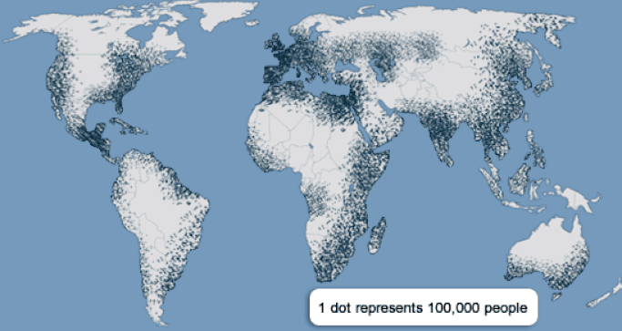
- Study the world maps showing population density/distribution and comment on the effects of a) latitude b) altitude. Explain the patterns you identify.
- Do you believe that physical or human factors have the greatest effect on population density? Justify your answer with reference to examples.