GEOGRAPHY MYP/GCSE/DP
  • MYP
    • Development >
      • Billionaires investigation
      • An unequal world?
      • Africa: the danger of a single story
      • Patterns of development
      • Trade and development
      • Fair Trade
      • Sustainable Development Goals
    • Tectonic Hazards >
      • What is risk?
      • Alfred Wegener and Continental Drift
      • Plate tectonics
      • Distribution of tectonic hazards
      • Measuring earthquakes
      • Why do people die in earthquakes?
      • School earthquake plan
      • Earthquake assessment
      • Volcanoes - what are they? Why are they important?
      • Volcano "Science Fair"
      • Causes of tsunami
    • Population >
      • Why study population?
      • Population distribution
      • Population growth
      • Population pyramids
      • Demographic transition model
      • Migration
      • Migration examples - case studies
      • Refugees in Indonesia
      • Population revision activities
    • Weather and Climate >
      • Weather vs Climate and why is it important?
      • Climate graphs
      • Why does it rain?
      • What affects temperature and why is Jakarta so hot and wet?
      • What causes wind and how do we measure it?
      • Microclimates
  • Home
    • Contact
  • IGCSE
    • Course information
    • Physical: Hazardous environments >
      • Distribution of tectonic hazards
      • Causes of tsunami
      • Measuring earthquakes
      • Earthquake case study 1: Haiti
      • Earthquake case study 2: Christchurch
      • Why do earthquakes do more damage in LICs than in HICs?
      • How are volcanic eruptions measured?
      • Tropical storms - distribution
      • Causes of tropical cyclones
      • Tropical cyclones - case study
      • Why live in hazardous areas?
    • River Environments >
      • Hydrological cycle
      • River basins
      • Factors affecting river regimes
      • Fluvial processes: erosion
      • Fluvial processes: weathering and mass movement
      • Fluvial processes: transportation and depositon
      • River features and their formation
      • How rivers change from source to mouth
      • Uses of water
      • Water pollution
      • Water supply
  • IBDP
    • Changing population >
      • Global patterns of economic development
      • Physical and human factors affecting global population distribution
      • Case study 1: China
      • Case study 2: Niger
      • Demographic transition
      • Megacity growth
      • Forced migration and internal displacement
      • Ageing populations
      • Pro-natalist and anti-natalist policies
      • Gender equality policies
      • Trafficking policies
      • The Demographic Dividend
    • Global climate vulnerability and resilience >
      • Atmospheric system
      • The energy balance
      • Changes in the energy balance
      • The enhanced greenhouse effect
      • Climate Change and the Hydrosphere, Atmosphere and Biosphere
      • Impacts of climate change on people and places
      • Disparities in exposure to climate change risk and vulnerability
      • Government-led adaptation and mitigation strategies
      • Civil society and corporate strategies
    • Global resource consumption and security >
      • Progress towards poverty reduction
      • Measuring trends in global consumption
      • Global patterns and trends in the availability and consumption of water
      • Global patterns and trends in the availability and consumption of land/food
      • Global patterns and trends in the availability and consumption of energy
      • Water food and energy nexus
      • Recycling and waste
      • Malthus vs Boserup
      • Resource Stewardship strategies
      • Sustainable Development Goals
    • Freshwater - drainage basins >
      • The drainage basin as a system
      • How rivers change from source to mouth
      • River discharge
      • River processes
      • River landforms
      • Factors affecting flood risk
      • Attempts at flood prediction
      • Flood mitigation
      • Flood mitigation case studies
      • Water scarcity
      • Agricultural activities and water quality
      • Pressures on lakes and aquifers
      • Internationally shared water and conflict
      • Water management: participation of local communities
      • Dams as multi-purpose schemes
      • Water management: Integrated Drainage Basin Management (IDBM)
      • Managing wetlands
    • Leisure, Sport and Tourism >
      • Growth and purpose of leisure time
      • Categories of tourism and sport
      • Economic development and participation
      • Factors affecting personal participation
      • Factors affecting growth of tourism hotspots
      • Spheres of influencee
      • Factors affecting a national sports league
      • Festivals
      • Niche national tourism strategies
      • Role of TNCs
      • Tourism as a national development strategy
      • International sporting events
      • Consequences of unsustainable growth
      • Sustainable tourism
      • Future international tourism
      • Political and cultural influences on sport
    • Extended Essay in Geography >
      • Supervisor meetings
    • Skills/concepts >
      • Infographics
      • 4 Ps
      • Mock examination revision and preparation
  • Geography and ToK
  • Theory of Knowledge
    • Knowledge and Technology
    • Knowledge and Language
    • Knowledge and Politics
    • Knowledge and Religion
    • Knowledge and Indigenous Societies

Microclimates

What you need to know

  1. What do we mean by microclimates?
  2. What factors cause microclimates in an area?
  3. How can we identify and measure microclimates?

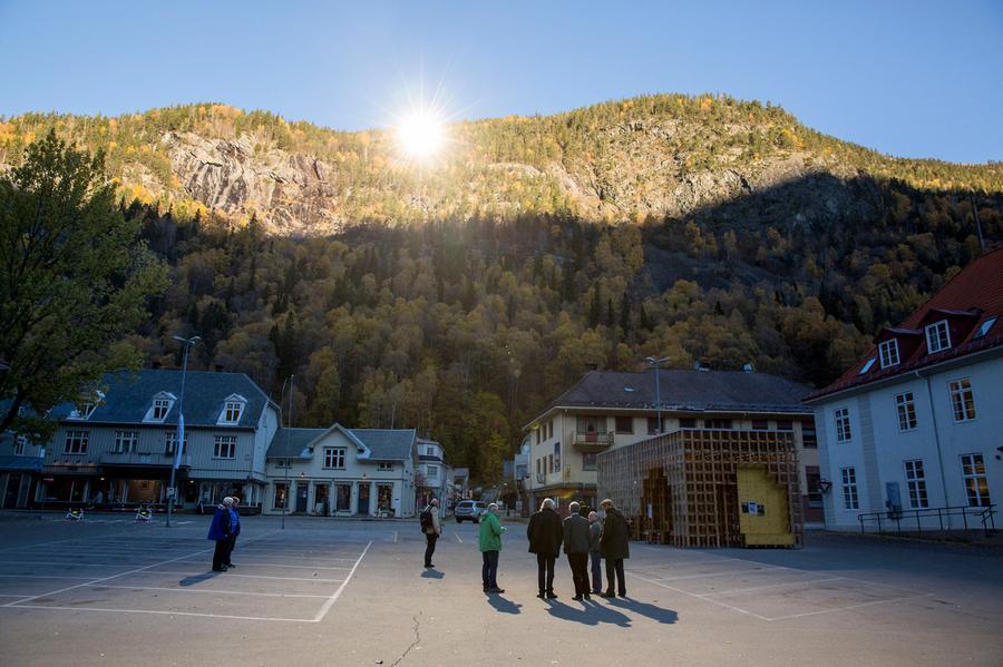
1. Why do they need mirrors in Rjuken, Norway?


​Watch the first video on the right very carefully. 
  • What happens to the sunshine as the car drives through the valley?
  • What is stopping the town from getting sunshine?
  • Try to draw a simple diagram to explain Rjukan's problem.
Picture


​Now watch the second and third videos below and consider the following questions:
  • Why did the people in Rjukan think that their lack of sunshine was a problem?
  • Describe their innovative solution (another diagram would be a great idea).
  • Now try to list other factors that will affect local weather conditions

2. Microclimates

So what is a microclimate?

​Form groups of three people and do the following:
  1. Give each person one of the videos below to watch
  2. Watch your video and use a mini-whiteboard to answer these questions:
    1. What is a good definition of microclimates?
    2. List factors that affect the local weather conditions. For each explain how it will affect it and why.
    3. Why are microclimates important for human activity?
  3. Once you have finished, share you information from your video with the other two people in your team and agree your answers to record in your books.


Microclimates from janeyk419


Use the slide to add detail to your answers from the videos above.

Check that everyone in your group of three has mentioned:
  • Physical features (use the example of Rjuken)
  • Shelter
  • Surface (albedo)
  • Buildings
  • Aspect

3. Microclimate investigation

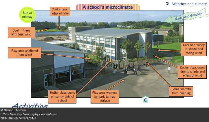
​Your mission is to investigate microclimates around school. Do microclimates exist? Can you gather recorded evidence of this? Can you plan an investigation?
Picture

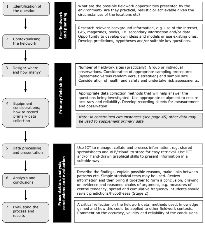
The stages of your geographical investigation will be:
  1. Identify your question or hypothesis that you will test.
  2. Examine the context of your investigation - what factors will affect microclimate? Why would we expect to find microclimates in school?
  3. Design your research - where will you go? How many sites? Who will be in our group? What about staying safe - assess the possible risks and plan to minimise them.
  4. Check you have the equipment you need and know how to use it and that you have a clear plan to record your data. Collect your data.
  5. Present your results using tables, graphs and maps.
  6. Analyse your findings and draw conclusions
  7. Evaluate how effective your investigation has been
Picture
Stages of a geographical investigation (from Edexcel IGCSE specification)
Use the document below to plan your investigation:
year_8_microclimates.docx
File Size: 604 kb
File Type: docx
Download File

Microclimate investigation - the report

Section 1: Introduction
This section should include:
  • A brief introduction to microclimates - what are they and why do they exist?
  • Your hypothesis for the enquiry

Section 2: Method
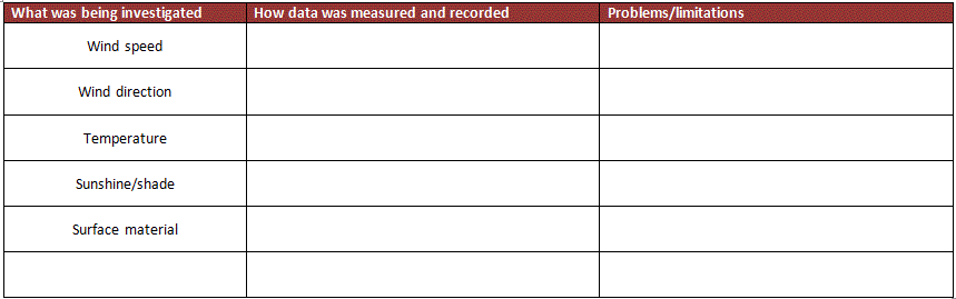
This section explains how you collected the data. You should include the following:
  • How you chose the sites you would visit to collect data
  • How you collected data for each aspect of the weather including
    • Equipment used
    • Exactly how you used the equipment
    • How you recorded the data
    • Any problems or limitations
One possible way to write your method is to use a table like the one below:
Picture
Section 3: Presenting your data
Think carefully about how you will present your data. This must be visual and include at least three different kinds of technique. Here are some ideas:

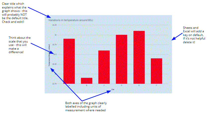
1) Bar chart - this is a simple technique which allows you to show variations in a single set of data. It is still important that it is done effectively though:
Picture
Think carefully about how you can choose the most effective scale for bar charts and other graphs:
Picture

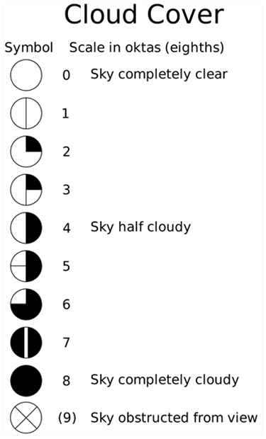
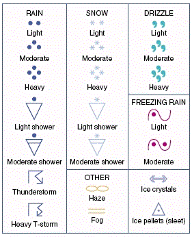
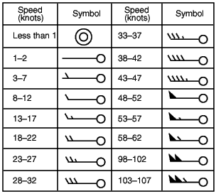
2) Weather map symbols
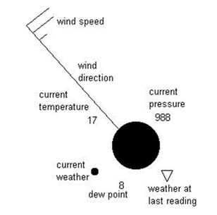
This is a great technique as it allows you to show data on a map. It is also an established way of showing data on weather which means you get to show off your knowledge and skills! Be careful though - you need to keep it VERY neat and clear so you will need to plan carefully.

Picture


​Each symbol will look a bit like this (but without the writing!). You could show wind speed, wind direction, sunshine and temperature like this.

Study the information below carefully and make sure you understand how to use these before getting started!
Picture
Picture
Picture

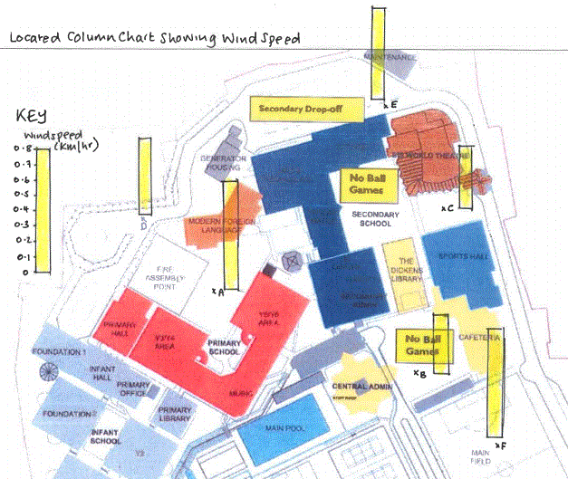
3) Located bar/column charts
These are great because they show the data and the location. You need to be very careful with neatness and accuracy. Remember that it will need a very clear title and key. An example of how it might look is below:
Picture


Remember:
  • Clear title
  • Select colour carefully so that it will be easy to see
  • Must be neat and clear
  • Key is essential and you will need to work out your own depending on your data - this might take a bit of trial and error!


4) Analysis
Describe – what patterns do the graphs show? For each graph fully describe and quote data
Explain – why are these patterns there? What factors have affected the temperature etc?
Connect – how does the data in the graph support or challenge your hypotheses?

5) Conclusion
Summarise your findings overall. Is there evidence of variation around the school site? To what extent does the evidence suggest that your hypothesis is true? Refer to your data here.

6) Evaluation
What are the weaknesses in your research methods? What factors would affect accuracy or the results (think about the equipment, how you used it, our sampling techniques). Suggest improvements and things we could do differently in order to make the report more accurate or to give a fuller set of results.


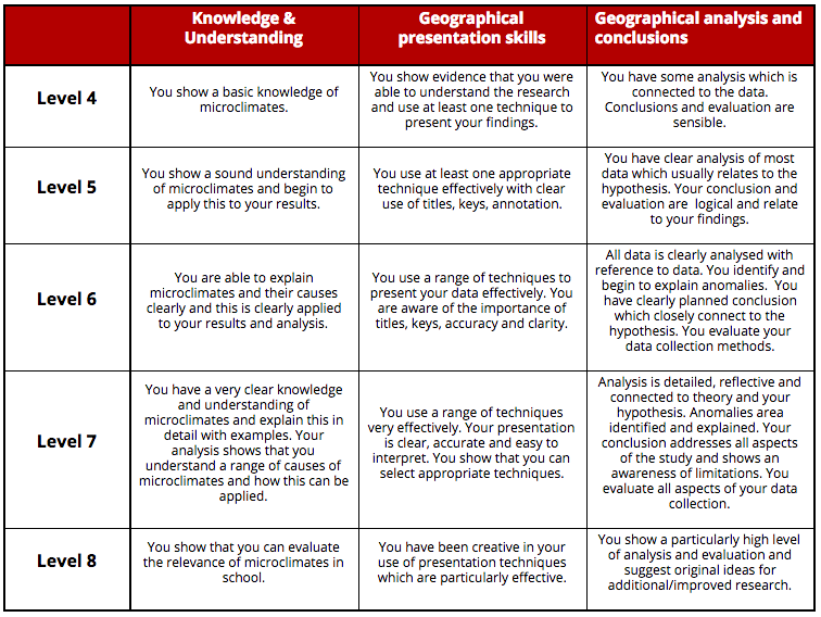
Assessment


​This is the rubric that will be used to assess your report.
Picture
  • MYP
    • Development >
      • Billionaires investigation
      • An unequal world?
      • Africa: the danger of a single story
      • Patterns of development
      • Trade and development
      • Fair Trade
      • Sustainable Development Goals
    • Tectonic Hazards >
      • What is risk?
      • Alfred Wegener and Continental Drift
      • Plate tectonics
      • Distribution of tectonic hazards
      • Measuring earthquakes
      • Why do people die in earthquakes?
      • School earthquake plan
      • Earthquake assessment
      • Volcanoes - what are they? Why are they important?
      • Volcano "Science Fair"
      • Causes of tsunami
    • Population >
      • Why study population?
      • Population distribution
      • Population growth
      • Population pyramids
      • Demographic transition model
      • Migration
      • Migration examples - case studies
      • Refugees in Indonesia
      • Population revision activities
    • Weather and Climate >
      • Weather vs Climate and why is it important?
      • Climate graphs
      • Why does it rain?
      • What affects temperature and why is Jakarta so hot and wet?
      • What causes wind and how do we measure it?
      • Microclimates
  • Home
    • Contact
  • IGCSE
    • Course information
    • Physical: Hazardous environments >
      • Distribution of tectonic hazards
      • Causes of tsunami
      • Measuring earthquakes
      • Earthquake case study 1: Haiti
      • Earthquake case study 2: Christchurch
      • Why do earthquakes do more damage in LICs than in HICs?
      • How are volcanic eruptions measured?
      • Tropical storms - distribution
      • Causes of tropical cyclones
      • Tropical cyclones - case study
      • Why live in hazardous areas?
    • River Environments >
      • Hydrological cycle
      • River basins
      • Factors affecting river regimes
      • Fluvial processes: erosion
      • Fluvial processes: weathering and mass movement
      • Fluvial processes: transportation and depositon
      • River features and their formation
      • How rivers change from source to mouth
      • Uses of water
      • Water pollution
      • Water supply
  • IBDP
    • Changing population >
      • Global patterns of economic development
      • Physical and human factors affecting global population distribution
      • Case study 1: China
      • Case study 2: Niger
      • Demographic transition
      • Megacity growth
      • Forced migration and internal displacement
      • Ageing populations
      • Pro-natalist and anti-natalist policies
      • Gender equality policies
      • Trafficking policies
      • The Demographic Dividend
    • Global climate vulnerability and resilience >
      • Atmospheric system
      • The energy balance
      • Changes in the energy balance
      • The enhanced greenhouse effect
      • Climate Change and the Hydrosphere, Atmosphere and Biosphere
      • Impacts of climate change on people and places
      • Disparities in exposure to climate change risk and vulnerability
      • Government-led adaptation and mitigation strategies
      • Civil society and corporate strategies
    • Global resource consumption and security >
      • Progress towards poverty reduction
      • Measuring trends in global consumption
      • Global patterns and trends in the availability and consumption of water
      • Global patterns and trends in the availability and consumption of land/food
      • Global patterns and trends in the availability and consumption of energy
      • Water food and energy nexus
      • Recycling and waste
      • Malthus vs Boserup
      • Resource Stewardship strategies
      • Sustainable Development Goals
    • Freshwater - drainage basins >
      • The drainage basin as a system
      • How rivers change from source to mouth
      • River discharge
      • River processes
      • River landforms
      • Factors affecting flood risk
      • Attempts at flood prediction
      • Flood mitigation
      • Flood mitigation case studies
      • Water scarcity
      • Agricultural activities and water quality
      • Pressures on lakes and aquifers
      • Internationally shared water and conflict
      • Water management: participation of local communities
      • Dams as multi-purpose schemes
      • Water management: Integrated Drainage Basin Management (IDBM)
      • Managing wetlands
    • Leisure, Sport and Tourism >
      • Growth and purpose of leisure time
      • Categories of tourism and sport
      • Economic development and participation
      • Factors affecting personal participation
      • Factors affecting growth of tourism hotspots
      • Spheres of influencee
      • Factors affecting a national sports league
      • Festivals
      • Niche national tourism strategies
      • Role of TNCs
      • Tourism as a national development strategy
      • International sporting events
      • Consequences of unsustainable growth
      • Sustainable tourism
      • Future international tourism
      • Political and cultural influences on sport
    • Extended Essay in Geography >
      • Supervisor meetings
    • Skills/concepts >
      • Infographics
      • 4 Ps
      • Mock examination revision and preparation
  • Geography and ToK
  • Theory of Knowledge
    • Knowledge and Technology
    • Knowledge and Language
    • Knowledge and Politics
    • Knowledge and Religion
    • Knowledge and Indigenous Societies