GEOGRAPHY MYP/GCSE/DP
  • MYP
    • Development >
      • Billionaires investigation
      • An unequal world?
      • Africa: the danger of a single story
      • Patterns of development
      • Trade and development
      • Fair Trade
      • Sustainable Development Goals
    • Tectonic Hazards >
      • What is risk?
      • Alfred Wegener and Continental Drift
      • Plate tectonics
      • Distribution of tectonic hazards
      • Measuring earthquakes
      • Why do people die in earthquakes?
      • School earthquake plan
      • Earthquake assessment
      • Volcanoes - what are they? Why are they important?
      • Volcano "Science Fair"
      • Causes of tsunami
    • Population >
      • Why study population?
      • Population distribution
      • Population growth
      • Population pyramids
      • Demographic transition model
      • Migration
      • Migration examples - case studies
      • Refugees in Indonesia
      • Population revision activities
    • Weather and Climate >
      • Weather vs Climate and why is it important?
      • Climate graphs
      • Why does it rain?
      • What affects temperature and why is Jakarta so hot and wet?
      • What causes wind and how do we measure it?
      • Microclimates
  • Home
    • Contact
  • IGCSE
    • Course information
    • Physical: Hazardous environments >
      • Distribution of tectonic hazards
      • Causes of tsunami
      • Measuring earthquakes
      • Earthquake case study 1: Haiti
      • Earthquake case study 2: Christchurch
      • Why do earthquakes do more damage in LICs than in HICs?
      • How are volcanic eruptions measured?
      • Tropical storms - distribution
      • Causes of tropical cyclones
      • Tropical cyclones - case study
      • Why live in hazardous areas?
    • River Environments >
      • Hydrological cycle
      • River basins
      • Factors affecting river regimes
      • Fluvial processes: erosion
      • Fluvial processes: weathering and mass movement
      • Fluvial processes: transportation and depositon
      • River features and their formation
      • How rivers change from source to mouth
      • Uses of water
      • Water pollution
      • Water supply
  • IBDP
    • Changing population >
      • Global patterns of economic development
      • Physical and human factors affecting global population distribution
      • Case study 1: China
      • Case study 2: Niger
      • Demographic transition
      • Megacity growth
      • Forced migration and internal displacement
      • Ageing populations
      • Pro-natalist and anti-natalist policies
      • Gender equality policies
      • Trafficking policies
      • The Demographic Dividend
    • Global climate vulnerability and resilience >
      • Atmospheric system
      • The energy balance
      • Changes in the energy balance
      • The enhanced greenhouse effect
      • Climate Change and the Hydrosphere, Atmosphere and Biosphere
      • Impacts of climate change on people and places
      • Disparities in exposure to climate change risk and vulnerability
      • Government-led adaptation and mitigation strategies
      • Civil society and corporate strategies
    • Global resource consumption and security >
      • Progress towards poverty reduction
      • Measuring trends in global consumption
      • Global patterns and trends in the availability and consumption of water
      • Global patterns and trends in the availability and consumption of land/food
      • Global patterns and trends in the availability and consumption of energy
      • Water food and energy nexus
      • Recycling and waste
      • Malthus vs Boserup
      • Resource Stewardship strategies
      • Sustainable Development Goals
    • Freshwater - drainage basins >
      • The drainage basin as a system
      • How rivers change from source to mouth
      • River discharge
      • River processes
      • River landforms
      • Factors affecting flood risk
      • Attempts at flood prediction
      • Flood mitigation
      • Flood mitigation case studies
      • Water scarcity
      • Agricultural activities and water quality
      • Pressures on lakes and aquifers
      • Internationally shared water and conflict
      • Water management: participation of local communities
      • Dams as multi-purpose schemes
      • Water management: Integrated Drainage Basin Management (IDBM)
      • Managing wetlands
    • Leisure, Sport and Tourism >
      • Growth and purpose of leisure time
      • Categories of tourism and sport
      • Economic development and participation
      • Factors affecting personal participation
      • Factors affecting growth of tourism hotspots
      • Spheres of influencee
      • Factors affecting a national sports league
      • Festivals
      • Niche national tourism strategies
      • Role of TNCs
      • Tourism as a national development strategy
      • International sporting events
      • Consequences of unsustainable growth
      • Sustainable tourism
      • Future international tourism
      • Political and cultural influences on sport
    • Extended Essay in Geography >
      • Supervisor meetings
    • Skills/concepts >
      • Infographics
      • 4 Ps
      • Mock examination revision and preparation
  • Geography and ToK
  • Theory of Knowledge
    • Knowledge and Technology
    • Knowledge and Language
    • Knowledge and Politics
    • Knowledge and Religion
    • Knowledge and Indigenous Societies

Tectonic Hazards Case Study 1: Haiti, January 10, 2010

Specification:
Case study of the management of an earthquake in a developing country

Picture

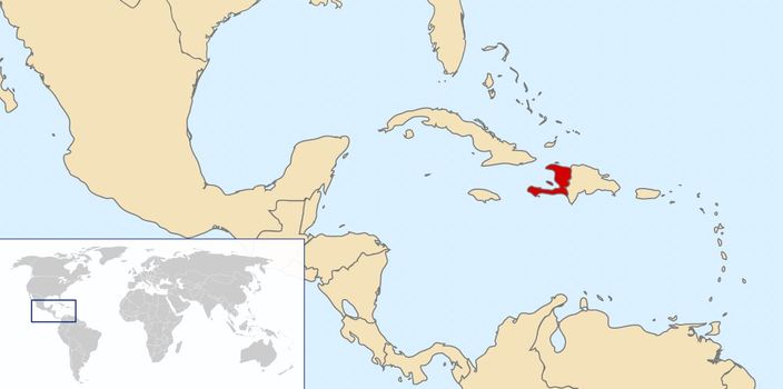
A. Where did the earthquake happen and why?

Use your copy of the map below to add the following labels:
  • Caribbean Sea
  • Mexico
  • Haiti
  • Dominican Republic
  • Florida
  • Jamaica
  • Cuba
  • Puerto Rico
Picture
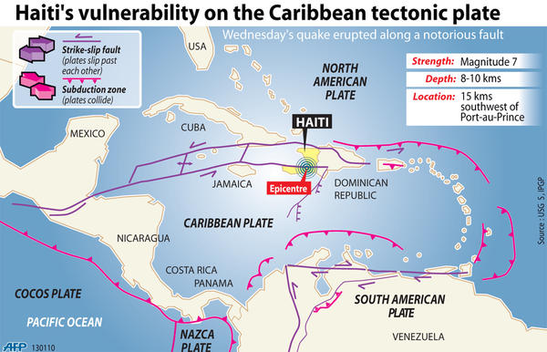
1. Watch the video and study the pate boundaries map below carefully. Use it to add the following to your base map:
  • Caribbean Plate
  • North American Plate
  • Destructive boundaries (subduction zone)
  • Conservative boundaries (strike-slip fault)
2. Decide what kind of plate boundary is responsible for the Haiti earthquake. Draw an annotated diagram to show why earthquakes happen at this boundary. Your diagram should include: North American Plate, Caribbean Plate, direction of movement, location of Haiti.
Picture

B. Why was Haiti vulnerable?

Use the CIA world factbook (link below) to produce a factfile on development in Haiti. You should compare Haiti to at least three other countries including USA, Sweden, Indonesia. Your factfile should include all of the following:
  • GDP per capita
  • Literacy rate
  • Hospital bed density (explain what this means)
  • Adult literacy rate
  • Unemployment rate
  • % of population with access to the internet
What conclusions can you draw on Haiti's level of development? How will this have affected its vulnerability to a major earthquake event? Explain your answer fully.
CIA World Factbook

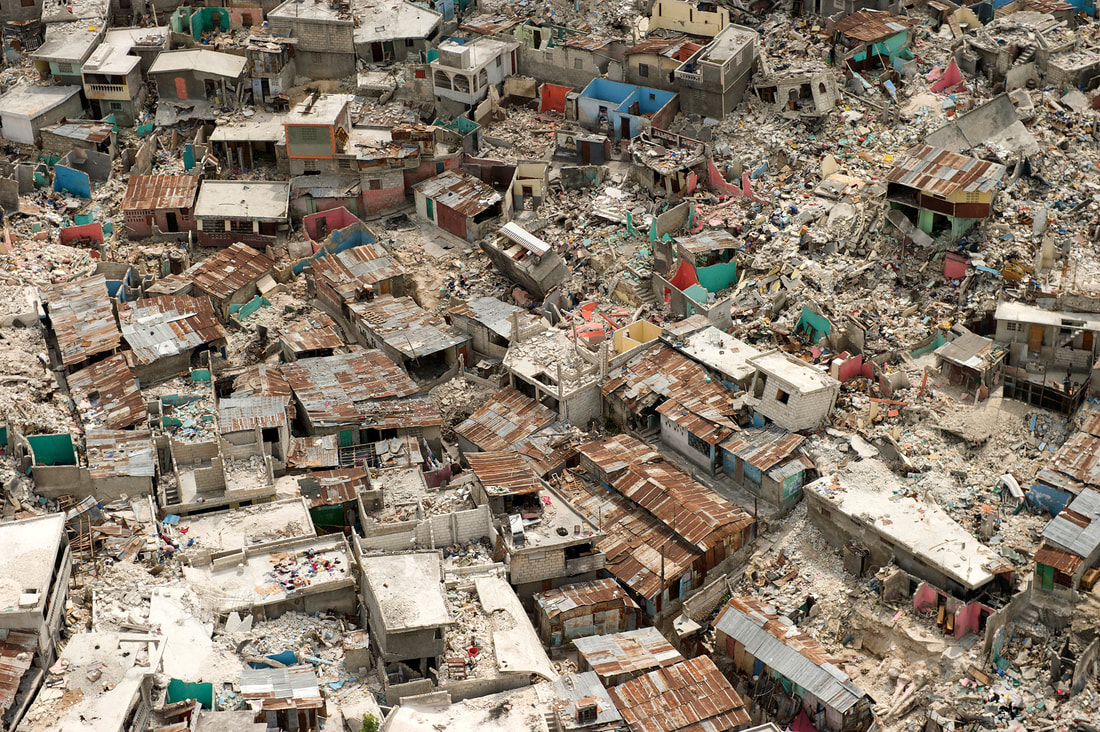
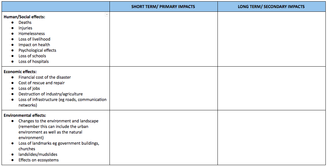
C. Effects of the Earthquake

Use your own copy of the table below to compile a detailed and clearly structured account of the impacts of the earthquake.
Picture

Fast facts

Haiti Earthquake: Facts, Damage, Effects on Economy
Britannica: Haiti earthquake of 2010
CNN: haiti earthquake fast facts
DEC: Haiti Earthquake facts and figures

News footage

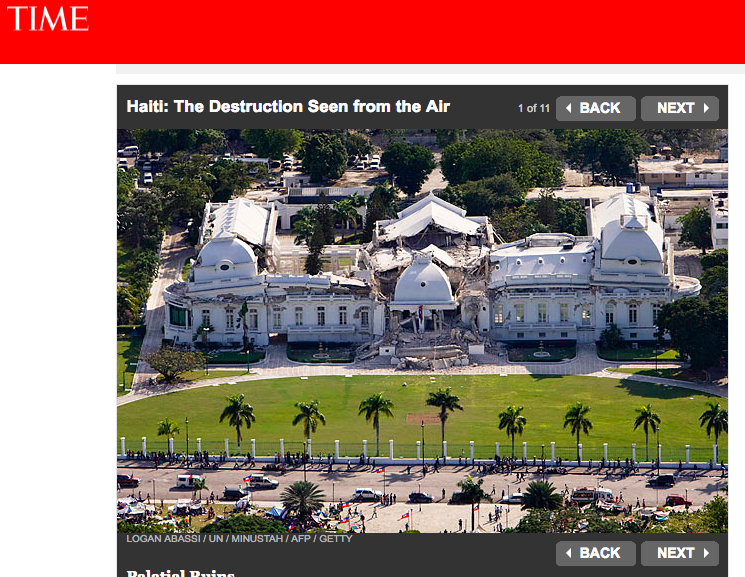
Photos of the damage

Picture

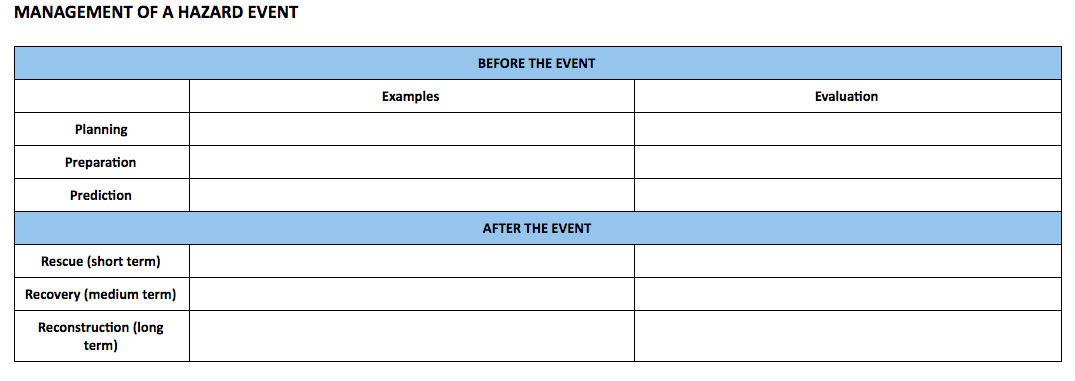
D. How was the earthquake managed?

Use the resources below to list and evaluate the ways in which the earthquake in Haiti was managed. Use your own copy of the table below.

We can divide the stages of earthquake management into the 3 Ps for before an event and the 3 Rs after it.


Before:
Planning - government and NGOs ensuring that detailed plans are in place in the event of a natural disaster. this might include evacuation plans, action plans for emergency services, stores of shelters, food, clean water.
Preparation - this is about readiness. It might include education of the people who live in an area including the use of the media, poster campaigns, school programmes, emergency drills. It might also include land use zoning to avoid building on unstable ground, building regulations to ensure that homes and public buildings can withstand a hazard event.
Prediction - this is about giving warning of an event. Although we cannot predict the exact time and location of an earthquake we can study patterns of where they have occurred.

After:
Rescue (short term)  - this is about acting immediately after the earthquake to ensure that survivors have medical care, food, shelter. It includes search and rescue, emergency services and organisations providing food, water and shelter immediately after the event.
Rehabilitation (Medium term) - this includes supporting people in ensuring that in the weeks/months after an event that they have shelter, food, water, sanitation, access to health care. It will also include the cleanup and repairs of damaged buildings, rubble, material left by landslides. It is about supporting people to recover and get on with their lives where possible. It might also include emotional support.
Reconstruction (Long term) - this is about rebuilding of homes, roads, water supply, sanitation and other infrastructure.
Picture
2010 Haiti earthquake response - case study from Social Media for Good
Criticism of Haiti's planning and preparation
Handy Geography - includes a list of responses
Cool geography case study - includes list of responses
BBC video 6 months after the quake
Reasons for slow response after the quake
Evaluation of aid efforts after the quake

E. Why was the Haiti earthquake so damaging?

Use the resources below to investigate why this earthquake, a 7.0 on the MMS did so much damage. Start by referring back to your factfile from Part B. You should create an infographic to explain the reasons that this earthquake was so destructive - the structure in the slide share below might be useful.
Why Were So Many People Killed In The In The Haiti Earthquake Of 2010 from Mr Cornish
"No surprise" that Haiti literally collapsed - SWI swissinfo.ch Text

Additional material

This video from the Al Jazeera correspondent contains some disturbing footage but raises valid questions on how the quake was managed.
Picture
  • MYP
    • Development >
      • Billionaires investigation
      • An unequal world?
      • Africa: the danger of a single story
      • Patterns of development
      • Trade and development
      • Fair Trade
      • Sustainable Development Goals
    • Tectonic Hazards >
      • What is risk?
      • Alfred Wegener and Continental Drift
      • Plate tectonics
      • Distribution of tectonic hazards
      • Measuring earthquakes
      • Why do people die in earthquakes?
      • School earthquake plan
      • Earthquake assessment
      • Volcanoes - what are they? Why are they important?
      • Volcano "Science Fair"
      • Causes of tsunami
    • Population >
      • Why study population?
      • Population distribution
      • Population growth
      • Population pyramids
      • Demographic transition model
      • Migration
      • Migration examples - case studies
      • Refugees in Indonesia
      • Population revision activities
    • Weather and Climate >
      • Weather vs Climate and why is it important?
      • Climate graphs
      • Why does it rain?
      • What affects temperature and why is Jakarta so hot and wet?
      • What causes wind and how do we measure it?
      • Microclimates
  • Home
    • Contact
  • IGCSE
    • Course information
    • Physical: Hazardous environments >
      • Distribution of tectonic hazards
      • Causes of tsunami
      • Measuring earthquakes
      • Earthquake case study 1: Haiti
      • Earthquake case study 2: Christchurch
      • Why do earthquakes do more damage in LICs than in HICs?
      • How are volcanic eruptions measured?
      • Tropical storms - distribution
      • Causes of tropical cyclones
      • Tropical cyclones - case study
      • Why live in hazardous areas?
    • River Environments >
      • Hydrological cycle
      • River basins
      • Factors affecting river regimes
      • Fluvial processes: erosion
      • Fluvial processes: weathering and mass movement
      • Fluvial processes: transportation and depositon
      • River features and their formation
      • How rivers change from source to mouth
      • Uses of water
      • Water pollution
      • Water supply
  • IBDP
    • Changing population >
      • Global patterns of economic development
      • Physical and human factors affecting global population distribution
      • Case study 1: China
      • Case study 2: Niger
      • Demographic transition
      • Megacity growth
      • Forced migration and internal displacement
      • Ageing populations
      • Pro-natalist and anti-natalist policies
      • Gender equality policies
      • Trafficking policies
      • The Demographic Dividend
    • Global climate vulnerability and resilience >
      • Atmospheric system
      • The energy balance
      • Changes in the energy balance
      • The enhanced greenhouse effect
      • Climate Change and the Hydrosphere, Atmosphere and Biosphere
      • Impacts of climate change on people and places
      • Disparities in exposure to climate change risk and vulnerability
      • Government-led adaptation and mitigation strategies
      • Civil society and corporate strategies
    • Global resource consumption and security >
      • Progress towards poverty reduction
      • Measuring trends in global consumption
      • Global patterns and trends in the availability and consumption of water
      • Global patterns and trends in the availability and consumption of land/food
      • Global patterns and trends in the availability and consumption of energy
      • Water food and energy nexus
      • Recycling and waste
      • Malthus vs Boserup
      • Resource Stewardship strategies
      • Sustainable Development Goals
    • Freshwater - drainage basins >
      • The drainage basin as a system
      • How rivers change from source to mouth
      • River discharge
      • River processes
      • River landforms
      • Factors affecting flood risk
      • Attempts at flood prediction
      • Flood mitigation
      • Flood mitigation case studies
      • Water scarcity
      • Agricultural activities and water quality
      • Pressures on lakes and aquifers
      • Internationally shared water and conflict
      • Water management: participation of local communities
      • Dams as multi-purpose schemes
      • Water management: Integrated Drainage Basin Management (IDBM)
      • Managing wetlands
    • Leisure, Sport and Tourism >
      • Growth and purpose of leisure time
      • Categories of tourism and sport
      • Economic development and participation
      • Factors affecting personal participation
      • Factors affecting growth of tourism hotspots
      • Spheres of influencee
      • Factors affecting a national sports league
      • Festivals
      • Niche national tourism strategies
      • Role of TNCs
      • Tourism as a national development strategy
      • International sporting events
      • Consequences of unsustainable growth
      • Sustainable tourism
      • Future international tourism
      • Political and cultural influences on sport
    • Extended Essay in Geography >
      • Supervisor meetings
    • Skills/concepts >
      • Infographics
      • 4 Ps
      • Mock examination revision and preparation
  • Geography and ToK
  • Theory of Knowledge
    • Knowledge and Technology
    • Knowledge and Language
    • Knowledge and Politics
    • Knowledge and Religion
    • Knowledge and Indigenous Societies